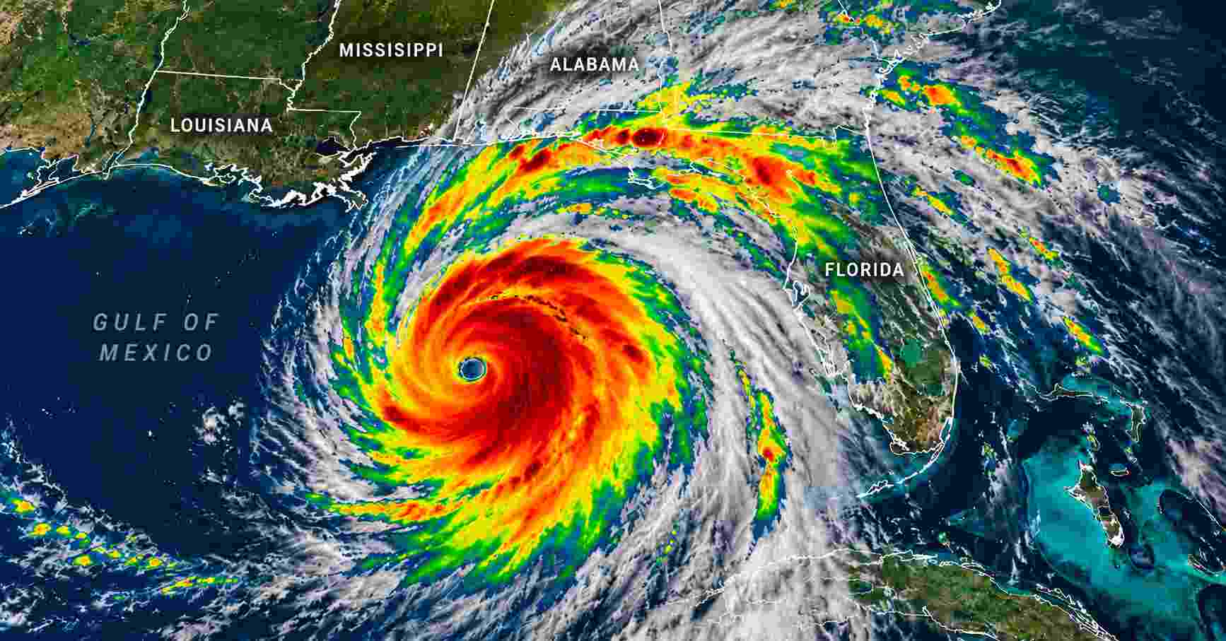
Hurricane Isaias is approaching the northern Gulf Coast of the United States, threatening communities in Mississippi, Alabama, Louisiana and Florida with destructive winds, dangerous storm surge and widespread flooding.
The powerful Category 2 hurricane continued strengthening early Friday, October 9, as authorities urged residents in vulnerable coastal communities to complete emergency preparations and follow evacuation instructions.
According to a report citing the National Hurricane Center’s 4 a.m. Central Daylight Time advisory, Isaias had maximum sustained winds near 110 mph (175 km/h). The storm was moving north-northeast at approximately 15 mph and could briefly reach Category 3 intensity before approaching land.
Forecasters expect the hurricane to make landfall along the northern Gulf Coast late Friday or early Saturday, October 10. Even if the storm weakens before reaching the shoreline, its combination of strong winds, coastal flooding and heavy rainfall could cause significant damage.
Where Is Hurricane Isaias Now?
Hurricane Isaias has been moving across the central Gulf of Mexico toward the southeastern United States.
At 1 a.m. CDT on Friday, the National Hurricane Center located the hurricane approximately 230 miles south of the mouth of the Mississippi River, with sustained winds of 105 mph.
Subsequent reporting on the 4 a.m. advisory indicated that winds had increased to approximately 110 mph, just below the 111 mph threshold for a Category 3 major hurricane.
The storm is expected to turn more northward as it approaches the Gulf Coast.
Forecast guidance places the greatest concern along the coastline between southern Mississippi and the western Florida Panhandle, including coastal Alabama.
However, the precise location and intensity of landfall remain uncertain. Small changes in the hurricane’s path could significantly affect which communities experience the strongest winds and highest coastal water levels.
Meteorologists also expect dangerous conditions to extend far beyond the storm’s center, particularly across areas to the east of its projected track.
Hurricane Isaias Landfall Forecast: When Will It Hit?
The National Hurricane Center expects Isaias to approach the northern Gulf Coast on Friday, October 9, before making landfall late Friday night or early Saturday morning.
The storm could briefly intensify into a major hurricane while traveling over warm Gulf waters.
However, increasing vertical wind shear may weaken the system before it reaches land.
Wind shear refers to changes in wind speed or direction at different heights in the atmosphere. Strong wind shear can disrupt a hurricane’s circulation and limit its ability to maintain intensity.
Despite the possibility of weakening, Isaias is expected to remain a dangerous hurricane at landfall.
Tropical-storm-force winds could begin affecting coastal communities Friday, ahead of the arrival of the storm’s center. Hurricane conditions are expected in portions of the hurricane warning area Friday night into early Saturday.
The hurricane’s forward movement could also carry strong winds and heavy rain into inland Alabama and Georgia during the weekend.
Hurricane and Storm Surge Warnings Issued Across the Gulf Coast
The National Hurricane Center has issued multiple warnings as Isaias approaches the United States.
Hurricane Warning
A hurricane warning is in effect from Ocean Springs, Mississippi, to the Bay/Gulf County line in Florida.
This includes vulnerable coastal areas of Mississippi, Alabama and the western Florida Panhandle.
Residents in the warning area should prepare for hurricane-force winds, falling trees, possible structural damage and prolonged electricity outages.
Storm Surge Warning
A storm surge warning extends from the mouth of the Mississippi River in Louisiana to the Suwannee River in Florida.
A storm surge watch also covers the area from the Suwannee River to Yankeetown, Florida.
Storm surge occurs when strong winds push seawater inland, raising water levels above normally dry coastal ground.
This flooding can affect homes, roads, businesses and essential infrastructure, sometimes before the strongest winds arrive.
Tropical Storm Warning
Tropical storm warnings cover additional coastal areas of southeastern Louisiana, Mississippi and Florida outside the hurricane warning zone.
These communities could still experience damaging gusts, heavy rainfall, hazardous driving conditions and power disruptions.
Warnings may change as the storm approaches, making official local updates particularly important.
Storm Surge Could Reach 5 to 7 Feet in Vulnerable Areas
Storm surge is among the most serious threats associated with Hurricane Isaias.
National Hurricane Center forecasts have indicated that water levels could rise approximately 5 to 7 feet above normally dry ground in some coastal areas between Ocean Springs, Mississippi, and Indian Pass, Florida, including parts of Mobile Bay.
The exact flooding depth will depend on the hurricane’s track, coastal geography and the timing of the surge relative to high tide.
Storm surge can become especially dangerous when powerful waves accompany rapidly rising water.
Low-lying neighborhoods, barrier islands, coastal highways and waterfront properties face heightened exposure.
Residents should not use a hurricane’s category alone to judge the danger. A weaker hurricane can still produce life-threatening coastal flooding.
Local evacuation orders should take priority over assumptions about the storm’s projected wind speed.
Heavy Rainfall Raises Flash Flooding Threat Across the Southeast
Hurricane Isaias is also expected to produce substantial rainfall across the southeastern United States.
The National Hurricane Center forecasts 4 to 8 inches of rain across southern Alabama, the Florida Panhandle, Florida’s Big Bend region and southwestern Georgia through the weekend.
Localized rainfall totals could reach 15 inches, particularly where bands of thunderstorms repeatedly move across the same locations.
Other parts of the Southeast could receive 1 to 3 inches, with locally higher amounts. Portions of the coastal Carolinas could also experience heavier rainfall.
These conditions increase the risk of flash flooding in urban neighborhoods, low-lying roads and areas with poor drainage.
River flooding is another concern, as heavy rainfall can continue affecting communities after the hurricane’s center moves inland.
Flooding can also interrupt transportation, emergency services and electricity restoration efforts.
Drivers should avoid flooded roads, even when water appears shallow. Floodwater can hide damaged pavement, strong currents and other hazards.
Tornadoes and Damaging Winds Could Extend Inland
The dangers from Hurricane Isaias will not be limited to communities directly along the Gulf Coast.
Forecasters warn that the storm’s outer rainbands could produce tornadoes beginning Friday evening in coastal Alabama, the Florida Panhandle and far southwestern Georgia.
The tornado threat could continue into Saturday across parts of eastern Alabama, Georgia and the Florida Panhandle.
Tropical systems can generate tornadoes within rotating thunderstorms, sometimes far from the hurricane’s center.
Meanwhile, strong wind gusts may extend into inland communities, potentially damaging trees, power lines and unsecured structures.
The National Hurricane Center has also warned of dangerous surf and rip currents along affected coastlines.
Residents should avoid entering the water during hazardous marine conditions and follow local beach restrictions.
Florida and Alabama Declare Emergencies as Evacuations Begin
State and local authorities have activated emergency preparations ahead of Hurricane Isaias.
Florida Governor Ron DeSantis declared a state of emergency covering 25 counties, allowing emergency management agencies to mobilize personnel, equipment and disaster response resources.
Mandatory evacuation orders were issued for designated vulnerable areas in Florida’s Okaloosa and Walton counties.
Alabama Governor Kay Ivey also declared a state of emergency covering 40 counties.
Coastal communities, including parts of Dauphin Island and the Gulf Shores area, have issued evacuation notices or encouraged residents in vulnerable locations to leave.
Georgia has also declared a state of emergency as officials prepare for potential inland impacts.
Emergency response agencies are preparing for flooding, road closures, power outages and possible damage to homes and infrastructure.
Residents are encouraged to follow instructions from county emergency management offices rather than relying solely on statewide forecasts.
Hurricane Isaias Disrupts Gulf Oil and Gas Production
The approaching hurricane has already affected offshore energy operations in the Gulf of Mexico.
According to Reuters, companies began evacuating personnel from offshore platforms and temporarily suspending production as the storm approached.
By Thursday, approximately 63% of current Gulf offshore oil production and 57% of natural gas production had been shut in, based on figures reported by the federal offshore energy regulator.
Major energy companies with operations in the region include BP, Chevron and Shell.
These precautionary shutdowns are intended to protect workers and equipment during severe weather.
The extent of any longer-term disruption will depend on storm damage, offshore inspections and how quickly operations can safely resume.
Temporary production interruptions do not automatically mean fuel shortages or higher gasoline prices, although significant damage to energy infrastructure could create additional supply concerns.
Why Is Hurricane Isaias Unusual for the 2026 Atlantic Season?
Hurricane Isaias is notable because it became the first Atlantic hurricane of 2026 unusually late in the season.
The Atlantic hurricane season officially runs from June 1 through November 30, with the greatest activity typically occurring between August and October.
Isaias reached hurricane strength on October 7, approaching a historical record associated with the late development of the season’s first hurricane in 1905.
Meteorologists have linked the unusually quiet Atlantic season partly to strong El Niño conditions.
El Niño can increase wind shear over portions of the tropical Atlantic, making it more difficult for hurricanes to form and strengthen.
However, favorable local conditions can still support the development of powerful storms.
Warm Gulf waters helped Isaias strengthen despite the broader atmospheric conditions that had suppressed hurricane activity earlier in the season.
The storm demonstrates why a relatively quiet hurricane season does not eliminate the risk of a damaging landfall.
What Residents Should Do Before Hurricane Isaias Arrives
Residents across affected communities should follow local emergency guidance and avoid unnecessary travel as conditions deteriorate.
Households in evacuation zones should leave when directed by authorities and use designated evacuation routes.
People sheltering in place should move important documents and essential supplies to secure locations, charge communication devices and prepare for possible power outages.
Outdoor furniture and other loose objects should be secured before strong winds arrive.
Residents who rely on electricity for essential medical equipment should make appropriate backup arrangements.
During the storm, people should remain away from windows and avoid traveling through flooded streets.
After conditions improve, residents should wait for official clearance before returning to evacuated neighborhoods.
What Happens After Hurricane Isaias Makes Landfall?
Forecasters expect Hurricane Isaias to weaken as it moves inland and loses access to the warm ocean waters that support its circulation.
However, weakening wind speeds will not immediately eliminate the storm’s hazards.
Heavy rainfall could continue across Alabama, Georgia and surrounding areas through the weekend.
Flooding may persist after the storm moves away, particularly where rivers and drainage systems respond slowly to intense rainfall.
Power restoration and transportation recovery could also take time in communities experiencing significant damage.
The final impact will depend on the hurricane’s actual landfall location, intensity, rainfall distribution and storm surge levels.
For the latest official information, residents should monitor the National Hurricane Center and local National Weather Service offices.
This report reflects information available on October 9, 2026, including early-Friday hurricane advisories. Forecast conditions, warnings and evacuation orders may change as new observations become available.